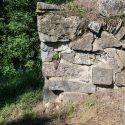
This stone bridge abutment elevated Morris Canal Bridge #6 over the canal so that boats could pass underneath.
Click left and right on the image to move to the next.
July 29, 2016
Author: Jim Lee III
Narrated by,
Jim Lee Jr.
July 29, 2016
Author: Jim Lee III
Narrated by,
Jim Lee Jr.

This stone bridge abutment elevated Morris Canal Bridge #6 over the canal so that boats could pass underneath.
This site is the former home of the late James S. Lee, Sr. (pictured left), Morris Canal author and historian. Plan 9 West is located on Rt. 519 1/2 mile south of Route 57 intersection east of Phillipsburg. The address for obtaining directions is 477 County Route 519, Stewartsville NJ 08886. Some facts about Plane…
The prism is the watered channel of the canal that carried boats between the canal’s locks and inclined planes.
This stone bridge abutment elevated Morris Canal Bridge #6 over the canal so that boats could pass underneath.
The ruins of a waste weir are located between Stryker’s Road and the bottom of Plane 9 West that helped regulate the level of water in the canal.
The Brakeman’s house is probably the original plane tender’s house for Plane 9 West.
The two-family Plane Tender’s House was built around 1850 for the plane tender and his family as well as another canal employee.
Canal boats were loaded on and off of cradle cars that carried the boats on rails up the inclined plane.
The tailrace carried water exhausted from the turbine down to the bottom of the inclined plane.
At the top of the turbine chamber there was a large wooden structure known as the Power House.
