Contact

Contact

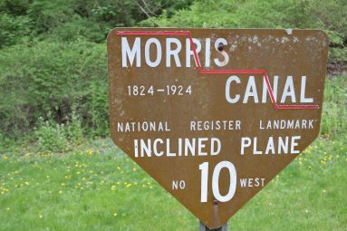
Thank you for your interest in The Morris Canal! We want to help you get all the answers you need. For more information on ExploreMorrisCanal.org, check out our about page. You can also read our answers to frequently asked questions (FAQ). Drop us a line, by filling out the form below if you’d like to know more!

Your Name (required)

Your Email (required)

Subject

Your Message

[recaptcha ]

Don’t forget to sign our Guestbook by clicking the image below!

Please sign our guestbook, Morris Canal


Explore Historic Morris Canal Sites

About Plane 9

About Plane 9

This site is the former home of the late James S. Lee, Sr. (pictured left), Morris Canal author and historian. Plan 9 West is located on Rt. 519 1/2 mile south of Route 57 intersection east of Phillipsburg. The address for obtaining directions is 477 County Route 519, Stewartsville NJ 08886. Some facts about Plane…

Sycamore Landing

Sycamore Landing

This stretch of the canal left the industrial areas of Phillipsburg behind for the pastoral farm fields of the upper Lopatcong Creek valley.

Lock Plane

Lock Plane

Before planes were powered by a scotch-reaction turbine, a water wheel was used to raise and lower boats.

Plane Tender’s House

Plane Tender’s House

Although greatly modified from its original appearance the plane tender’s house at the top of Plane 10 West still exists today.

About Plane 10

About Plane 10

Plane 10 West’s turbine chamber is filled by a natural spring and may contain remains of the original turbine. See pictures of this Morris Canal site by scrolling through the photo Gallery. Click left and right on the image to move to the next. From the Delaware River the Morris Canal climbs uphill, one level…

Bottom of Plane 10

Bottom of Plane 10

The bottom of Plane 10 West is still visible across Lopatcong Creek from an early stone springhouse.

Lock St. Kiosk

Lock St. Kiosk

A great variety and number of historic features and sites are located along Lock Street.

Canal Prism (West of Stryker’s Road)

Canal Prism (West of Stryker’s Road)

The prism is the watered channel of the canal that carried boats between the canal’s locks and inclined planes.

Bridge abutment

Bridge abutment

This stone bridge abutment elevated Morris Canal Bridge #6 over the canal so that boats could pass underneath.

Waste Weir at Stryker’s

Waste Weir at Stryker’s

The ruins of a waste weir are located between Stryker’s Road and the bottom of Plane 9 West that helped regulate the level of water in the canal.